
The Black Route - 158 Km / 98.4 miles
|
The Black route is 98.4 miles long and has a total ascent of 5925 feet
|
|


Contains Ordnance Survey data Crown copyright and database right 2018
click on the map for a detailed view
PLEASE NOTE: Due to a road closure for bridge repairs, you will now travel west after leaving Dunning, bypass Auchterarder to the south of the A9 and then join the Glen Eagles road towards the Yetts of Muckhart.
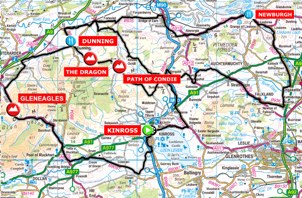
Just like the Red route this route heads east from Kinross and then heads north and through the village of Glenfarg before turning right at Arngask. It then follows minor roads through the Ochils before reaching the historic town of Falkland. On leaving Falkland a long rolling section lays ahead until you reach the first feed station at Newburgh. Then its on through Bridge of Earn, Forgandenny and Forteviot before reaching the town of Dunning with its 12th. Century church of St. Serf and the monument to Maggie Wall who was burnt here as witch in 1657. Legend also has it that St. Serf slayed a dragon here who was bothering the locals.
Here at Dunning and after the second feed station you deviate from the combined Red / Black course for a 34 km loop where you can slay your own monsters with the ascent of the feared but aptly named Dragon Hill. A further climb at the Path of Condie and you are descending to Glenfarg. After departing Glenfarg there is the undulating road over Rosie Ochil and back to Dunning to pick up the combined Blue / Red / Black route.
After leaving Dunning, for the second time, you will travel west and keeping south of Auchterarder. You will then join the Glen Eagles road and climb over the top and then down to the Yetts of Muckhart before returning to Kinross through the Crook of Devon.


